Ukraine blocked Russian contingent to Transnistria (Moldova)

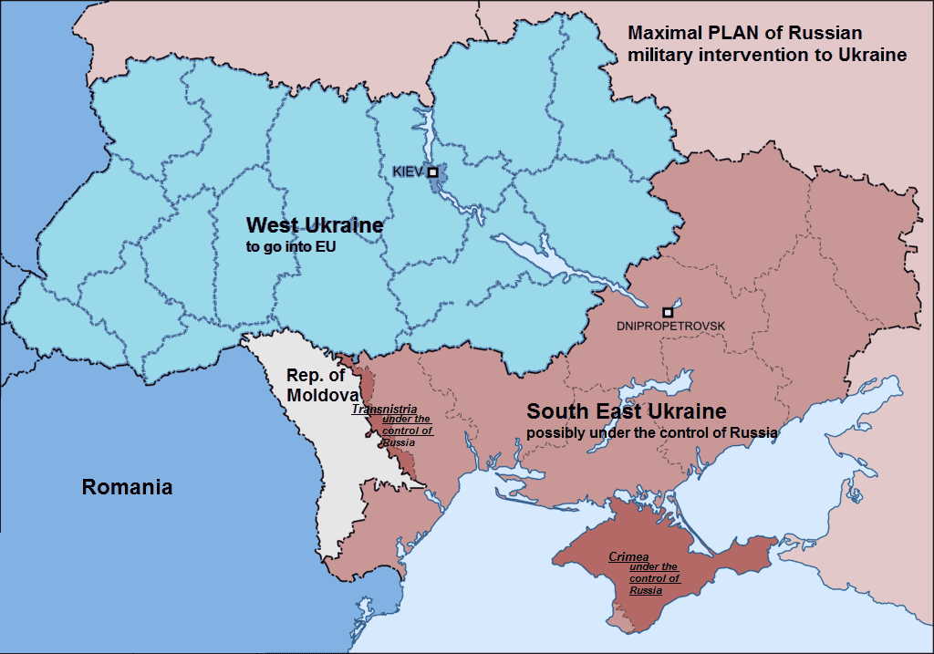
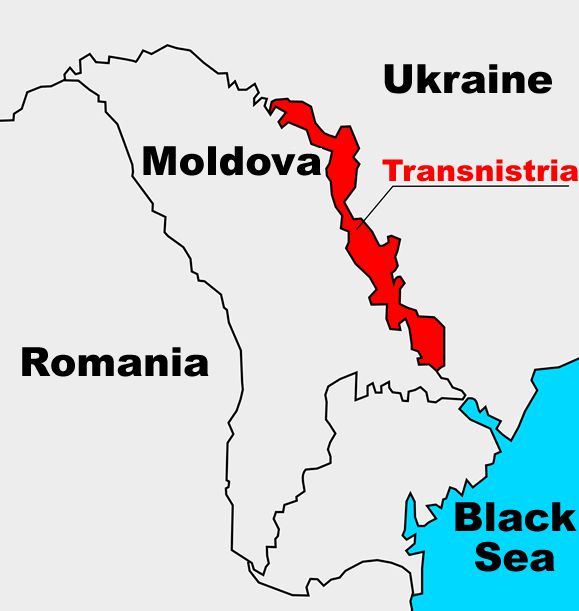
As it is well-known Russia has about 1,500 troops stationed in the unrecognised separatists’ republic Transnistria (Republic of Moldova), post-Soviet “frozen conflict” zone, that has eastern Moldovan border with Ukraine.

Verkhovna Rada of Ukraine (Ukrainian Parliament) adopted the law on denunciation of five agreements between Ukraine and the Russian Federation on May 21, 2015.

  • Agreement on transit of Russian military units temporarily located on the territory of the Republic of Moldova through the territory of Ukraine (04 December 1998)
  • Agreement on mutual protection of classified information (15 November 2001)
  • Agreement on cooperation in military intelligence (7 February 2002)
  • Agreement on the organization of military interstate transportation and payments for them (12 September 2002)
  • Agreement on military cooperation (25 November 1995)

In addition the Cabinet of Ministers of Ukraine made a decision to terminate military technical cooperation with Russia.


See also: Ukraine pledges corridor if Russia troops pulled out from Transnistria


At the cabinet meeting on May 20 the Prime Minister of Ukraine Arseniy Yatsenyuk said that this was done because of the Russia’s aggression towards Ukraine:

“Once, there was such the agreement on military technical cooperation between Ukraine and the Russian Federation. It was signed on May 26, 1993. The Cabinet of Ministers of Ukraine reaches a decision to terminate this agreement. The Russian Federation is an aggressor state, the Russian Federation illegally annexed the Crimea, Russia carried out military intervention in Donetsk and Luhansk regions, Russia poses a threat to Ukrainian state and its territorial integrity. That is why the agreement on military technical cooperation with Russia is terminated by the Cabinet of Ministers of Ukraine,” said Arseniy Yatsenyuk.

As for now, Russia has no legal way to take away 1,500 soldiers home or send new troops to Transnistria. Transit of Russian military units through Ukrainian territory was the only way for Russian troops during last years.

One of the the the possible scenarios of the further Russia’s aggression toward Ukraine is to grab the entire southern coast of Ukraine and have the connection in the breakaway region of Transdniestria.

Avatar photo

UaPositon

An independent media focused on Ukraine.
Follow us on social media:
Facebook
Twitter
Instagram

2 Comments

  1. Whenever I see “east/west” (in reference to Ukraine), I “see” subliminal brainwashing of Americans with another kremlin canard.

    Canards have been the policy, procedure, and practice of the kremlin – for centuries.

    When most Americans think “civil war”, then they think “north/south” – with a clear dividing line. Putin even selected the confederate flag for one of the so-called republics – to reinforce the disinformation with “subliminal brainwashing”.

    They use the kremlin’s “east/west” Rhetoric regarding language, religion, “ethnic civil war”, etc…

    The following two (2) official maps clearly contradict the “east/west” fabrications, and expose other disinformation canard.

    File:UkraineNativeLanguagesCensus2001detailed-en.png

    http://en.wikipedia.org/wiki/File:UkraineNativeLanguagesCensus2001detailed-en.png

    And this map :

    http://en.wikipedia.org/wiki/Ukraine#mediaviewer/File:Ukraine_ethnic_2001_by_regions_and_rayons.PNG

    Post a Reply
  2. Likewise, whenever I see the “north/south” line in reference to “Novorossia” (New Russia), I “see” subliminal brainwashing of Americans [and the west] with another kremlin canard, also.

    Canards have been the policy, procedure, and practice of the kremlin – for centuries.

    The kremlin has been rewriting the history Muscovy [AKA – Russian Federation] and Ukraine – for centuries. In fact, all older maps were kept in a “KGB archive” that students were not allowed to see. When the USSR [AKA – Muscovy] disintegrated in 1991, these maps became available to scholars. The following maps are an “eye opener”.

    German map 1918.
    http://upload.wikimedia.org/wikipedia/commons/7/74/Ukraine_1918_de.jpg

    French map
    File:Carte de ukraine 1919.jpg
    http://en.wikipedia.org/wiki/File:Carte_de_ukraine_1919.jpg

    Please note that Kuban [and other parts of “Russia”] is part of Ukraine in the French map from 1919 [and the German map from 1918]. Based on the 1926 census, parts of Kuban were 90% Ukrainian – and the other “10%” were not all Russian, obviously. The kremlin resolved that “problem” with the Genocide called Holodomor [murder by maliciously orchestrated starvation].

    Ukrainians in Kuban according to census of 1926.

    http://en.wikipedia.org/wiki/File:Kuban_1926.png

    Post a Reply

Submit a Comment

Your email address will not be published.

Share This

Share this post with your friends!